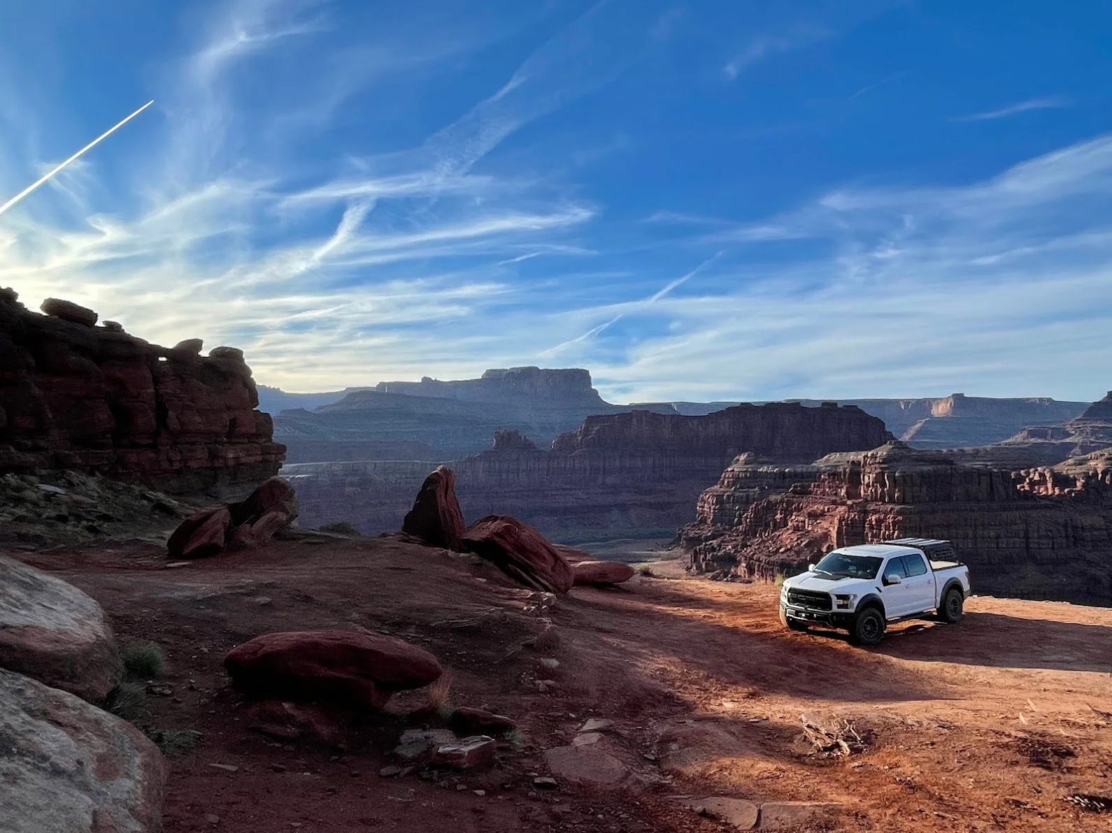

The Wider WABDR - Section 4A
While all sections of the WABDR are passable by just about any vehicle with moderate clearance and decent tires, this is probably my favorite go-to section and it’s one of the most scenic.
The Wider WABDR - Section 4A
Departure Time:
As early as you’re comfortable, allowing for at least 4 hours of trail time in the light.
Vehicle Checklist:
See our Off-Road Gear List!
A saw, chainsaw, and axe are very useful on this route in fall, winter, and spring as downed trees and encroaching brush are common and often easy to clear.
A Garmin InReach or other device for reaching out for help without cell service
Emergency gear for cold weather
A camera or drone is really handy on this scenic drive
DOWNLOAD THE GPS TRACKS AND KNOW HOW TO USE THEM ON YOUR GPS, ON-X, or GAIA!! - https://ridebdr.com/download-tracks/ - I cannot stress this enough. You CAN get lost on this trail!
A physical map as backup: Butler WABDR Map
Dan's Notes:
While all sections of the WABDR are passable by just about any vehicle with moderate clearance and decent tires, this is probably my favorite go-to section and it’s one of the most scenic. It’s a perfect drive for taking the family to play, and there are multiple opportunities to turn around if things get to tough or blocked. You should expect this route to take 2-4 hours in ideal conditions and about 4-6 hours in heavy snow. Your times may vary drastically depending on your skill level or how many times you stop to take pictures.
The Drive:
Coming over Highway 2 or I-90, I recommend dropping into 97 Rock House to start and end your day. They have good food, coffee, ice cream, and drinks with a great location for groups of friends and a friendly staff. It’s the perfect staging ground. Next, be sure to top off your fuel in Cashmere at the Chevron or Shell. If you’re coming from Leavenworth, the Safeway is typically a little cheaper.
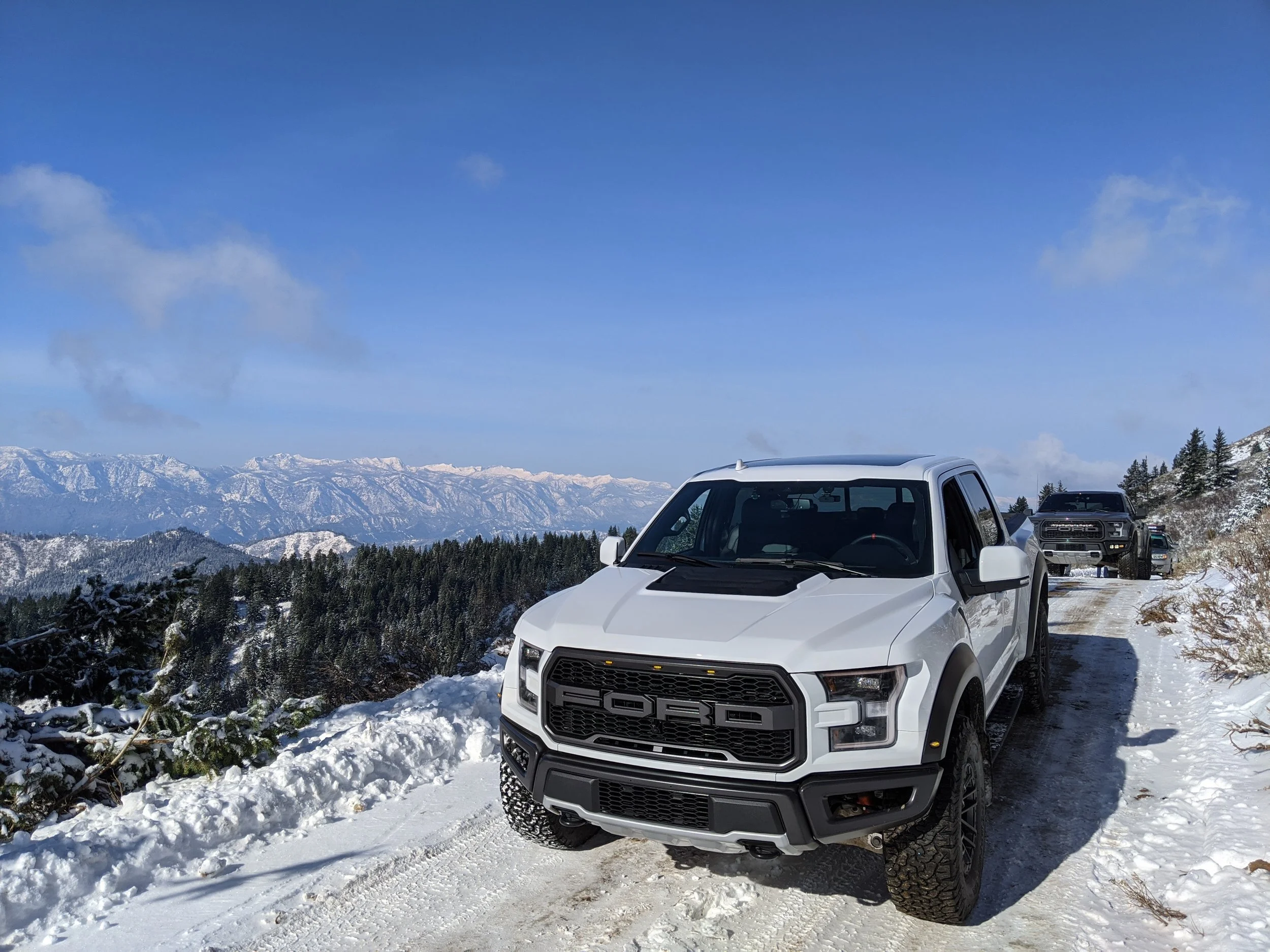
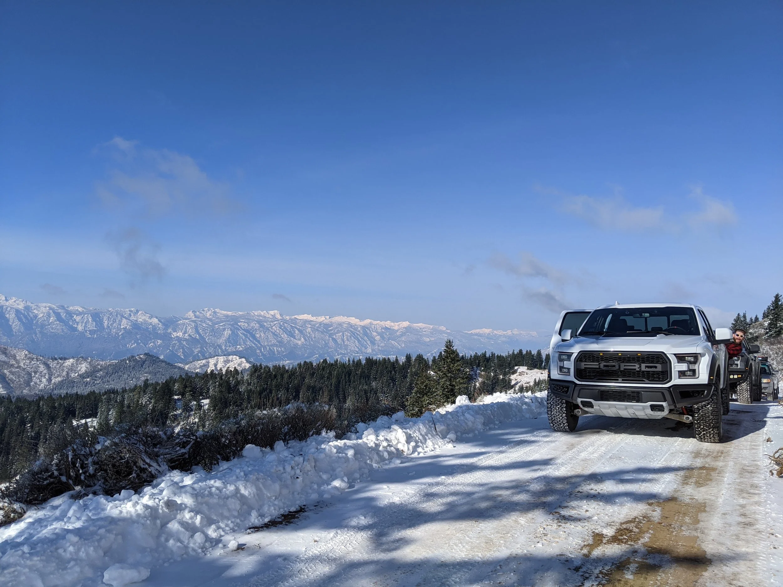
As you head up out of Cashmere the trail can be rutted, but look for bypasses as there are typically multiple ways around obstacles on this well traveled trail. I recommend airing down to 15-20 PSI mainly for comfort when the pavement ends, but in snowy conditions you should drop down even lower, to whatever you are comfortable with as a “low pressure”. In the Raptor and Land Cruiser, 12psi worked well at low speed for deep snow.
As you end the drive you can continue on to the rest of Section 4, but you should be aware it will take an extra 4-5 hours if you do, and you will probably get trail stripes in a larger vehicle. You won’t get body damage without being reckless, but keep in mind what I said about the trail stripes if you’re driving a wide vehicle like the Raptor. As I’ve put it on the map, you’ll snake down to Ardenvoir where there is a general store with limited hours in the off season, but they’ve got the basics (but no fuel). I’d head back to 97 Rock House for dinner and drinks to end the day.


The Backyard Overlander
This is my go-to local drive when I want to test something on the Land Cruiser or just go play in the snow with friends.

THE BACKYARD OVERLANDER
Departure Time: Earlier is better for photos, fresh snow, and less 4x4 traffic, but you can take this road any time of the day or night.
Car Checklist:
Tires in excellent condition
Decent suspension travel - potholes on this road and can destroy a stock height car. Don't say I didn't warn you.
Emergency gear for cold weather
An air compressor for airing up after airing down your tires for traction.
Dan's Notes:
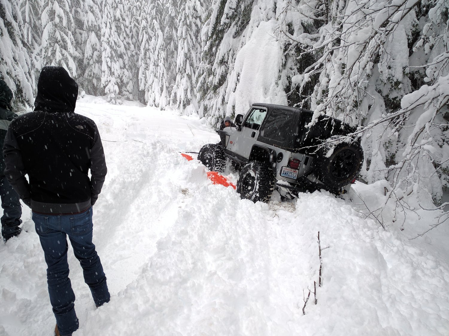
This is my go-to local drive when I want to test something on the Land Cruiser or just go play in the snow with friends. It's busy enough that you don't have to worry about getting in too much trouble and remote enough that you're not stuck in too much traffic. That said, don't skimp on the list above and if you get stuck you can expect to get very stuck most of the time. Ditches on both sides of the road and some narrow points will leave you searching for traction if you need to yield to oncoming traffic. It's also mandatory to air down low in deep snow like this or you will in fact get very stuck. Alright, onto the drive!
The Drive:
Head East on I-90 and take the time to stop and fill up in North Bend. There's a Safeway, Starbucks, McDonald's, etc all right off the exit so you'll have plenty of opportunity to get any supplies you'll need. NEVER head up into the mountains without a full tank of gas... and drinks.. and coffee.. and probably some jerky or something.
Get back on 90 until you reach exit 42, Tinkham Road. Use caution in the winter exiting here as it's a downhill offramp that's almost never plowed or de-iced and you get into quite the pucker factor moment if you're not ready. Ask me how I know!
Take a right at the bottom and you'll be on Tinkham. Just cross the small bridge to the parking lot and you'll have time to air down if needed. Keep going down until you reach NF-5510; it's not marked, but you'll likely still have cell service being close to I90 and it will show on your GPS... but let's discuss before you decide what to do now.
In the winter, NF-5510 is not plowed and I genuinely DO NOT recommend going up it unless you're with a group and someone in that group has a winch, not just a tow strap. Even if you do make it all the way up to the turn around at the top, the downhill section gets heavily packed by 4x4s and will turn to a solid sheet of ice. Go very, very, very slow when coming down the hill and don't panic when you start sliding forward. I actually drove down this section in reverse while going forward, using reverse as a brake. The only option to stop is to ditch it to the right going down, left will take you off an embankment.

So now that you know, you might want to just keep going, or if you're feeling brave take that right and get to the lower parking lot. It's a flat drive in to that, so momentum will be your friend in deep snow.
Once you've had your fill keep going and look for the fun little water crossing. It's nothing challenging, but how often do you get to drive across a flowing river with pavement under it so you know you won't get stuck? It makes for some fun photos and videos, so enjoy it!
As you exit Tinkham there is sometimes a built up snowbank used not to block the road, but just to keep less capable vehicles out. It also makes a great little jump or so I hear. Take a left off of Tinkham and get back on I90 and keep going East! You're just a few miles from Snoqualmie Pass, so may as well stop at Dru Bru for some lunch and good beer. Cheers!

Where The Deer and The Antelope Play
I’ve been wanting to take this drive for years, so I finally did while living in McCall for a month. This deceptively long, 75 mile drive takes you up and around the Payette lakes and over to Riggins on Highway 95.

Where the Deer and the Antelope Play
Departure Time:
Earlier the Better or the evening sun will be in your face for most of the drive
Car Checklist:
Some kind of satellite communication device (no cell service)
Good tires and a full size spare
A tire patch/plug kit
A hand saw, axe, or chainsaw
An extendable pry bar or tow strap (for removing the rare small boulder if necessary)
Water
A full tank of fuel
A drone if you have it - you’ll get incredible footage here.
Dan’s Notes:
I’ve been wanting to take this drive for years, so I finally did while living in McCall for a month. This deceptively long, 75 mile drive takes you up and around the Payette lakes and over to Riggins on Highway 95. The views here are some of the best in the area, and it’s a relatively easy drive for anything with some decent tires. This is the perfect drive for a Subaru or stock 4wd. This would also be a really fun drive for those lucky few of you with Safari built 911s.
When it comes to coffee, start your day at Fogglifter Cafe in McCall. They really are the best in town and the line moves quick. If you haven’t grabbed breakfast, you’ll want to do that as well as this drive typically takes 4-5 hours in good weather.
Be careful as you make your way up and around Payette Lake on Warren Wagon Rd. Not only is the speed limit low and the police count high, but it’s low for a reason. I saw moose, deer, elk, ground squirrels, and fox on this road almost every single time I drove up it and they’re not exactly afraid of cars or standing mid corner. It’s low for a reason and the view is beautiful the whole way up anyway, so give it a rest and enjoy the view here.
As you reach the end of the pavement you’ll make the turn onto Burgdorf Rd/NF-246. Don’t let the scary sign fool you as just about any modern vehicle with even mild ground clearance can drive this road with relative ease. It’s not that bumpy (for a gravel road) and well maintained even. In the Raptor it might as well have been a gravel highway.
Speaking of gravel highways, there is A LOT of dust kicked up on this route. If you’re driving a truck everything in the bed is going to be covered in dust, cover or not. I made the mistake of keeping my recovery gear back there once and ended up washing it all in the driveway. Not the most fun use of time.
As you get up to Burgdorf Hot Springs, you’ll notice it’s unfortunately closed in the summers or accessible via reservation only. Still, it’s a cool spot to see on your way over the mountain. The road continues to climb slowly until you start the long switchback road down. Careful on the corners here as they are often blind and VERY narrow, meaning someone will have to back up to a pull out point. Be courteous here. Idaho is a friendly place even if is not all that diverse.
As you come down from the gravels roads and across the river you’ll find the road change very quickly to a 1.5 lane blacktop road. A perfect, winding, AMAZING blacktop road that is in great condition. In the right vehicle, this is a hell of a drive, but it was still fun in the Raptor. This road is pretty busy with people coming to fish, but I still had a good time and I’m sure you will too.
Route Hard Link: https://goo.gl/maps/hwffQMozmb1BG3R49


The War Eagle
This route is rough, but not necessarily difficult, barely even requiring 4wd. While the many dips and sharp rocks do warrant a proper off-road tire, just about anything with proper tires should get you up to the top of War Eagle Mountain.
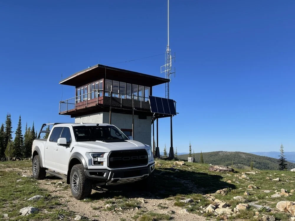
The War Eagle
Departure Time:
Any time works for this drive, but it would be great at sunrise or sunset if you have auxiliary lighting.
Car Checklist:
Some kind of satellite communication device (no cell service)
Good tires and a full size spare
A tire patch/plug kit
A hand saw, axe, or chainsaw
An extendable pry bar or tow strap (for removing the rare small boulder if necessary)
Water
A full tank of fuel
A drone if you have it - you’ll get incredible footage here.
Dan’s Notes:
This route is rough, but not necessarily difficult, barely even requiring 4wd. While the many dips and sharp rocks do warrant a proper off-road tire, just about anything with proper tires should get you up to the top of War Eagle Mountain.
Taking notes from the drive over to Riggins, you’ll want to start with coffee and understand that you will be gone a while. While this is a short drive in distance, it’s also a slow drive due to boulders, narrow roads, and unforeseen delays. I used my axe and my saw to get to the top, so I always recommend you carry them, but this is a popular and relatively well maintained trail by hunters, offroaders, and snowmobiles in the winter.
The one thing I want to make sure people take note of on this drive is how rough this trail is; take it easy. There are THOUSANDS of ground squirrels counting on you an the potholes will break shocks if you’re not ready for them. A slow and steady pace will reward you with beautiful views and curious wildlife.
Also take note that the fire tower is a LIVED IN structure by the rangers. Holler for them as you arrive and let them know you came to visit. Bring cookies or something; show them we appreciate them!


